Reconstruction Of The Gulf Oasis From The Late Pleistocene To Early Neolithic Time Periods
According to Dr. Jeffrey Rose, there were three zones of human occupation below the Persian Sea. He stated in his paper titled, “New Light on Human Prehistory in the Arabo-Persian Gulf Oasis”, that below the Persian Sea in what he refers to as the Gulf Oasis was, “ground zero to the Agricultural and Urban revolutions”(1) of the human race. He stated, “The Gulf Oasis model envisages that the wave of Middle Holocene settlements derive from an indigenous population displaced by the advancing shoreline. From that perspective, Terminal Pleistocene and Early Holocene sites around the Gulf represent but the more mobile, peripheral elements of a larger core group deep within the basin, as the gulf oasis had one of the largest and most stable sources of freshwater in southwest Asia for the majority of the Late Pleistocene and the Early Holocene time periods."(2)
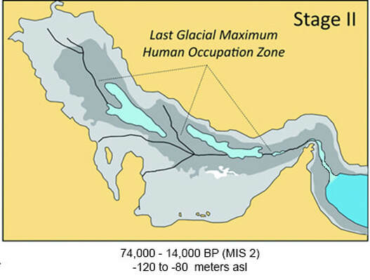
Figure 1: Occupation zones within the Persian Gulf(Jeffrey Rose, 2010)
Dr. Rose was not alone in this idea as several other eminent archaeologists have made similar predictions in the past. One of those archaeologists was V. Gordon Childe, a man widely regarded as one of the most important archaeologists and prehistorians of his generation.(V. Gordon Childe. 1928) Another archaeologist who had made a similar claim was Dr. Theresa Howard-Carter, a distinguished scholar of the ancient near east. In her 1981 article in the Journal of Cuneiform Studies titled, "The Tangible Evidence for the Earliest Dilmun," she stated, "the gulf was an entirely dry basin about 15,000 BC. The Tigris and the Euphrates carved their course separately and together to the Straits of Hormuz, where they debouched directly into the gulf of Oman. It is more than likely that the original gulf oasis inhabitants lived along the banks of the lower or extended Shatt-al-Arab, ranging some 800 km across the dry gulf bed. We can thus postulate that the pre-Sumerian cultures had more than ample time to be born and flourish in this ravine setting, encouraged by the agricultural potential, and the blessings of a temperate climate. The fact that the body of proof for the existence of these societies must now lie at the bottom of the gulf furnishes at least a temporary excuse for the archaeologist's failure to produce evidence of this culture. For the next 6000 years, between 14,000 to 8000 BC, the gulf gradually filled from the Indian Ocean in the south. During this period the land formation of the west side of the gulf remained constant and the climate continued to be temperate, but due to the persistent oceanic instability of the Iranian side, the eastern littoral was a far less inviting habitat. The populations retreating from the flooded lower Shatt-al-Arab were therefore forced to higher ground in the western and northern part of the gulf.”(3)
The fact that many archaeologists proposed the same location for an ancient settlement to have existed under the Persian Sea held my attention. It seemed to line up with what Peter Oefner, PhD, senior research scientist in the Department of Biochemistry and associate director of the Stanford Genome Technology Center, Peter Underhill, PhD, senior research scientist in the Department of Genetics, and Dr. Spencer Wells, a well known geneticist, had stated. All three of these men, along with many others, independently concluded that the route the first wave of humans, haplogroups M130, M174 and M, took when they left Africa around 50 - 60,000 years ago passed through the exposed landscape of the Persian Gulf. Through their research they were able to show that these ancient peoples traveled east across the Red Sea, through the southern portion of the Arabian Peninsula, and then along the shoreline towards Australia.(Spencer Wells - 2004).
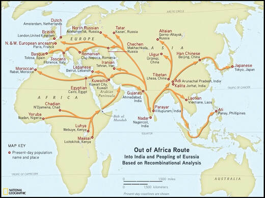
Figure 2: Out Of Africa Route, National Geographic.
If this is the case, then one of the earliest groups of humans came in contact with the exposed landscape of the gulf oasis 50-60,000 years ago, if not even earlier. As Dr. Douglas Martinson’s research paper titled, “Age Dating and Orbital Theory of the Ice Ages,” explains that this exposure of the Persian Gulf floor was only possible due to global ocean levels having dropped to approximately 85-90 meters below present levels from the ice age the world found itself in.(Douglas G. Martinson. 1987)
Assuming that all of the above mentioned scientists and archaeologists are correct, and our ancient ancestors discovered this oasis on their way to India and eventually Australia, then reason stands that some of them had to have remained in order to have occupied this oasis. An oasis that is now lost to us. This would mean an important chapter in the human story now lays at the bottom of the Persian Gulf. A chapter that could only begin to be written by recreating this lost world. Unfortunately, it is impossible to find a detailed bathymetric map that is available to non-military personnel like myself that would allow us to see what this lost world was like and begin to fill in this lost chapter of our history.
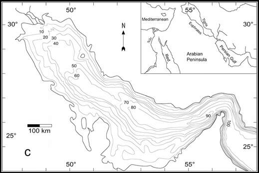
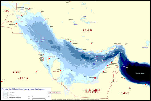
Figure 3 and 4: Illustration of bathymetric maps available on the Persian Gulf.
That is until Google Earth was created.
It is fortunate that in the last 10 years technology has become so sophisticated that we now have a tool that allows us to map the world above and below the ocean. By using the path tool, in combination with the elevation tool that Google Earth provides, a detailed bathymetric map of the Persian Gulf floor can emerge. This reconstruction of the eastern side of the gulf oasis was constructed in 1 meter intervals and as far as I am aware, the map that I was able to produce is the first of its kind.
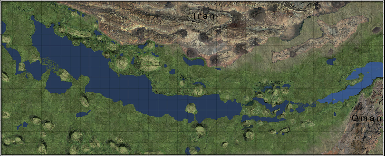
Figure 5: Gulf Oasis with the ocean at a depth of -85 meters below current sea levels, circa 50,000 BCE.(Dold. 2016, Douglas G. Martinson. 1987)
Having the ability to now observe what this lost world looked like, we can see that Dr. Jeffrey Rose was correct when he tells us, “Given the extent of the exposed land within the Gulf basin, the abundance of food, water, lithic raw material, and its conscripted geographic position, this sizable inland depression is thought to have formed one of the most important oases in the ancient world. Situated along the eastern edge of the peninsula, the Arabo-Persian Gulf is among the shallowest seas in the world, with average depths of just 40 m. When global sea levels dropped below this mark at the onset of MIS4, more than 100,000 km of land were continuously exposed for the ensuing 70,000 years. During that interval, the basin housed a rich mosaic of freshwater springs, river floodplains, mangrove swamps, marshes and estuaries (Al-Hinai, Moore, and Bush 1987; Alsharhan and Kendall 2003; Butler 1969; Diester-Haass 1973; Evans 1966; Georgiev and Stoffers 1980; Gischler et al.2005; Lambeck 1996; Saleh et al.1999; Sarnthein 1972; Seibold and Vollbrecht 1969; Stoffers and Ross 1979; Sugden 1963;Uchupi, Swift, and Ross 1996, 1999; Williams1999; Wilkinson and Drummond 2004).”(4)
Paradise Revealed
In order to understand how some of our earliest ancestors came to populate this now subterranean landscape, we need to look at the research NOAA conducted on the Greenland ice core samples. According to their research presented in figure 6, the Earth has spent most of its time locked in one ice age or another.
In order to understand how some of our earliest ancestors came to populate this now subterranean landscape, we need to look at the research NOAA conducted on the Greenland ice core samples. According to their research presented in figure 6, the Earth has spent most of its time locked in one ice age or another.
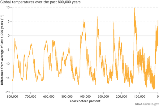
Figure 6: Greenland Ice core data(NOAA)
These ice ages have lasted 10’s of thousands of years, and in each one the Earth's global temperature dropped to such a level that the water in the oceans that cover the Earth began to freeze. This freezing was so extensive that large ice sheets would eventually cover large parts of the northern and southern hemispheres. This transformation of ocean water into ice dramatically lowered the global ocean level. This natural process drained the Persian Gulf of its waters by 80,000 BCE and exposed the seafloor for thousands of years.
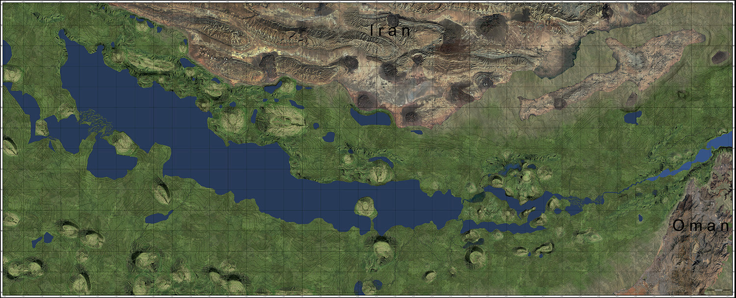
Figure 7: Gulf Oasis with the ocean at a depth of -100 meters below current sea levels, circa 40,000 BCE.(Dold. 2016, Douglas G. Martinson. 1987)
By the height of the last ice age, 20,000 years ago, the ocean had receded to a maximum depth of 140 meters below current sea levels, where an abrupt warming of the planet began, and the Ice caps that covered large parts of the globe began to melt. This reversal in global temperatures caused the ocean levels to slowly rise.(Fairbanks, R.G. 1989, Douglas G. Martinson. 1987)
If Dr. Spencer Wells is correct, and one of the earliest human migrations out of Africa ended up in this Oasis at about 60,000 BCE. The people who decided to stay in this paradise and not continue their journey east into India, would have occupied this region of the world from about 60,000 BCE to approximately 10,000 BCE, a span of 50,000 years or more.
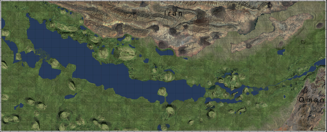
Figure 8: Gulf Oasis with the ocean at a depth of -140 meters below current sea levels, circa 20,000 BCE.(Dold. 2016, Douglas G. Martinson. 1987)
The End Of Paradise
Though this land would have been paradise to our early ancestors, all good things must come to an end. We know this because today the gulf oasis is now covered by salt water. This means that at some point in our not too distant past, this part of the world was no longer inhabitable for humans and animals alike as the ocean began to reclaim it.
The question then becomes, what did this dramatic rise in ocean level look like in this part of the world and how did it impact those who lived in this oasis?
Now that a detailed map of this location is available to us, it is relatively simple to recreate the flooding of the Gulf Oasis by tracing out each contour line in the map and filling in the outlined space with an image of water. However, in order to find the rate of ocean rise and the dating of this ocean rise required answers from those that have studied this very topic. One such expert who has successfully shown the rise of the ocean into the Gulf Oasis is Dr. Lambeck. He has researched, and subsequently published a paper titled, “Shoreline reconstructions for the Persian Gulf since the last glacial maximum." In his research, he took core samples throughout the Persian Gulf and studied its composition, not only looking at what each core sample was composed of but when the ocean reclaimed each area the sample was taken from.(Lambeck. 1996) Below in figure 9, is a summary of Dr. Lambecks findings.
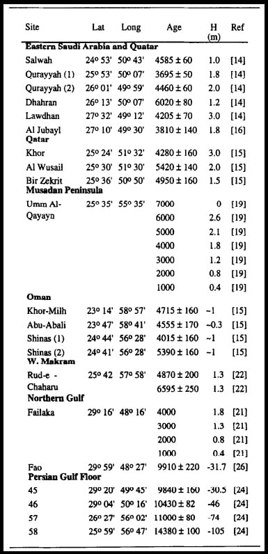
Figure 9: Summary of observational evidence for sea-level change in the Persian Gulf and surrounds(Lambeck. 1996 )
The data that Lambeck acquired at sites 45, 46, 57, and 58 are invaluable. The data collected shows what depth the ocean was in the gulf oasis and the time in which it had occupied this depth. Fortunately, Lambeck was not alone in this field of study. Another renowned scientist also collected data on the ocean's rise. Fairbank's paper titled, “ A 17,000-year glacio-eustatic Sea Level: influence of glacial melting rates on the Younger Dryas event and deep ocean circulation” shows us the history of the Atlantic ocean and its subsequent rise for the last 15,000 years.
In Figure 10 below, I have combined both Fairbank's and Lambeck's work.(Lambeck. 1996; Fairbanks, R.G. 1989) This was done to show how each scientist's work related to one another in regards to time and depth, so as to validate or disprove the credibility of each man's work. It is amazing the uncanny similarity between them, thus validating each man's work and allowing us to use their research with confidence. Though I would like to point out that site 45 and 46 in Lambeck's data differs slightly to that of Fairbank’s. Lambeck's results for site 45 and 46 follow the same curvature of ocean rise as Fairbank's work does, however, Lambeck's results show that the ocean reclaimed the Persian gulf at these depths approximately 500 years before the time frame Fairbank's data shows.(Lambeck. 1996; Fairbanks, R.G. 1989) Though speculation on my part, this could be explained by a larger rebounding of the earth's crust in the Persian Gulf due to the rapid melting of the North American ice sheets, which Lambeck took into consideration when publishing his findings, as opposed to what might have occurred in the Bahamas where Fairbanks collected his data.(Lambeck. 1996) Regardless of the reason, it is fair to say that both parts of the world experienced similar rises in ocean level, thus allowing one to derive an approximate speed and time for each meter of ocean rise in the gulf oasis.
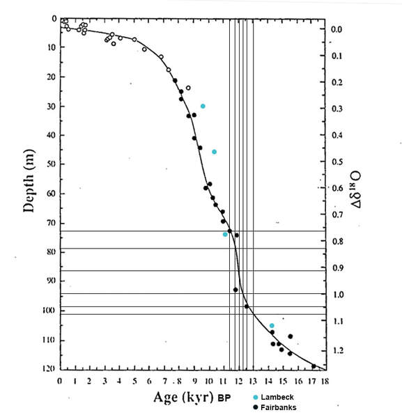
Figure 10: This is a chart that shows the results of both Lambeck's and Fairbank's findings in relation to ocean level and age.(Lambeck. 1996; Fairbanks, R.G. 1989)
When looking at the data in figures 9 & 10, the ocean level existed at a depth of -108 meters below current sea levels approximately 14,300 years ago. In figure 10 it seems to indicate that by 13,000 BP the ocean level had risen to a depth of -101 meters. An average of 185 years for every meter in rise. Not very fast. Though according to both men’s research things started to radically change at about 13,000 BP. Therefore I would like to begin the reconstruction of the flooding of the gulf oasis as seen in figure 11 below at a depth of -101 meters which seems to have occurred at approximately 13,000 BP.
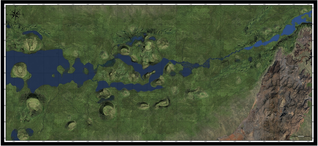
Figure 11: Gulf Oasis with the ocean at a depth of -101 meters below current sea levels, circa 13,000 BP.(Dold. 2016, Lambeck. 1996; Fairbanks, R.G. 1989)
Going forward from 13,000 BP to 12,000 BP, according to Fairbanks research, the ocean rose approximately 15 meters. Starting from -101 meters to -86 meters below current sea levels. This would mean that the ocean rose an average of 1 meter every 65 years. Using this data we can reconstruct what the gulf oasis looked like 12,000 years ago seen in figure 12 below.
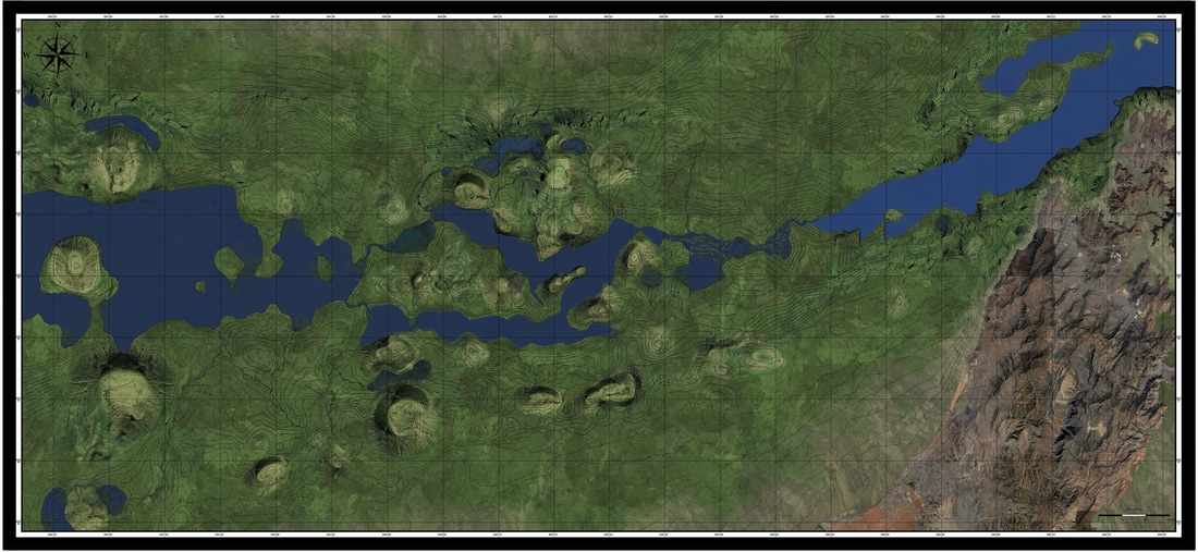
Figure 12: Gulf Oasis with the ocean at a depth of -86 meters below current sea levels, circa 12,000 BP.(Dold. 2016, Lambeck. 1996; Fairbanks, R.G. 1989)
As you can see the deep canyon that exists in the Straits of Hormuz held the rising ocean rise at bay, not allowing it to affect the greater gulf oasis. However, over the next 1000 years things radically changed. According to both Fairbank’s and Lambeck’s work, from 12,000 BP to 11,000 BP the ocean rose another 12 meters. Rising from -86 meters to -74 meters below current sea levels, an average of 1 meter every 80 years. It is this rise that I would like to illustrate meter by meter in the following images below.

Figure 13: In the above image we see the Gulf Oasis with the ocean at a depth of -85 meters below current sea levels, circa 11,920 BP.(Dold. 2016, Lambeck. 1996; Fairbanks, R.G. 1989)
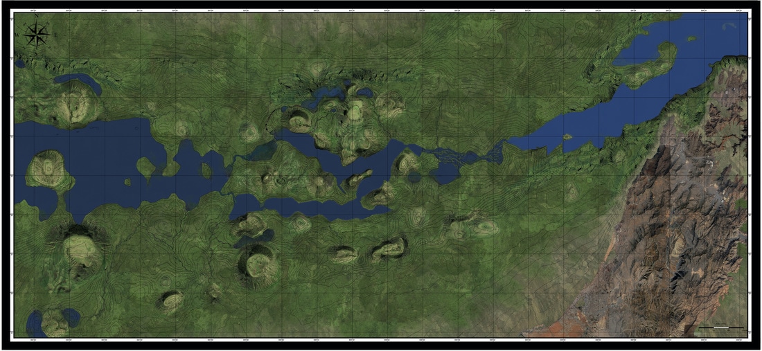
Figure 14: In the above image we see the Gulf Oasis with the ocean at a depth of -84 meters below current sea levels, circa 11,840 BP.(Dold. 2016, Lambeck. 1996; Fairbanks, R.G. 1989)
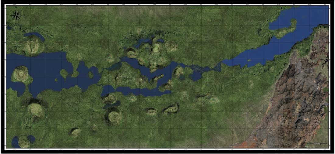
Figure 15: In the above image we see the Gulf Oasis with the ocean at a depth of -83 meters below current sea levels, circa 11,760 BP.(Dold. 2016, Lambeck. 1996; Fairbanks, R.G. 1989)
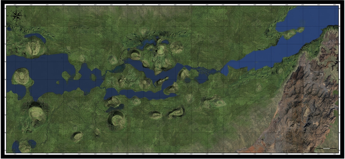
Figure 16: In the image above we see the Gulf Oasis with the ocean at a depth of -82 meters below current sea levels, circa 11,680 BP.(Dold. 2016, Lambeck. 1996; Fairbanks, R.G. 1989)

Figure 17: In the above image we see the Gulf Oasis with the ocean at a depth of -81 meters below current sea levels, circa 11,600 BP.(Dold. 2016, Lambeck. 1996; Fairbanks, R.G. 1989)
By -80 meters below current sea level the rising ocean had little effect on the gulf oasis. It is still contained within the canyon that exists in the eastern portion of the Straits of Hormuz. This can be seen in figure 18 below.
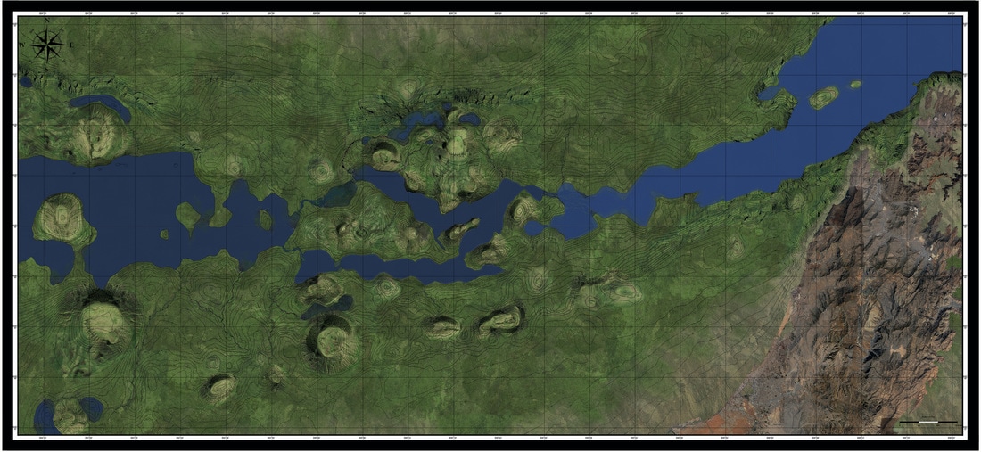
Figure 18: Gulf Oasis with the ocean at a depth of -80 meters below current sea levels, circa 11,520 BP.(Dold. 2016, Lambeck. 1996; Fairbanks, R.G. 1989)
However, in the next 80 years things begin to take a dramatic turn for the worst. As illustrated in figure 19 below you can see that within a 10-15 years span the ocean rises from -80 m to -79.8 meters(½ foot) and floods the first of several large lakes that existed in this area. This influx of saltwater into a freshwater ecosystem would have killed all of the plants and animals within the freshwater lake and caused any land animal that drank from its shores to abandon it as a source of freshwater.

Figure 19: Gulf Oasis with the ocean at a depth of -79.8 meters below current sea levels, circa 11,510 BP.(Dold. 2016, Lambeck. 1996; Fairbanks, R.G. 1989)
In the next 70 years the ocean would have continued to rise to a depth of -79 meters below current sea levels as seen below in figures 20.
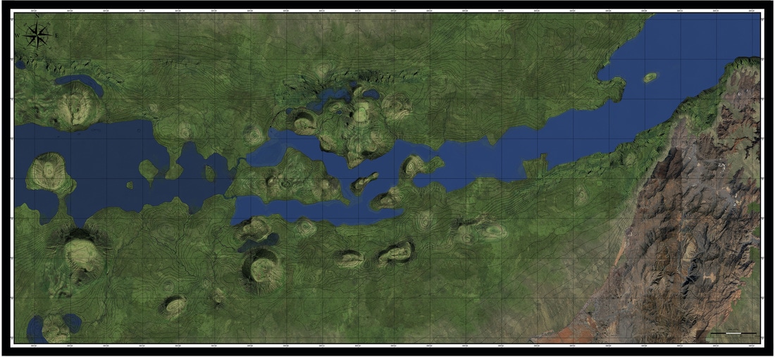
Figure 20: Gulf Oasis with the ocean at a depth of -79 meters below current sea levels, circa 11,440 BP.(Dold. 2016, Lambeck. 1996; Fairbanks, R.G. 1989)
When the ocean reached -79 meters approximately 11,440 BP and rose another ½ foot to a depth of -78.8 meters, in a 10 to 15 year span the greatest fresh water lake this part of the world knew for more than 50,000 years died as it was flooded from the ever rising ocean. If the previous death of the first of these great lakes was not the end to a way of life for all that depended on it, then the catastrophic event illustrated in Figure 21 and 22 below must have solidified the beginning of the end to a way of life our ancestors developed in this part of the world.

Figure 21: Gulf Oasis with the ocean at a depth of -77.8 meters below current sea levels, circa 11,430 BP.(Dold. 2016, Lambeck. 1996; Fairbanks, R.G. 1989)
Figure 22: Gulf Oasis with the ocean at a depth of -77.8 meters below current sea levels, circa 11,430 BP.(Dold. 2016, Lambeck. 1996; Fairbanks, R.G. 1989)
Astonishingly, it is this devastating event that I believe Dr. Rose and Dr. Howard-Carter refer to when they discuss an indigenous population being displaced by an advancing shoreline. An event that marked the end to a way of life our early ancestors had developed over the course of 50,000 years, an event that spanned a single person's life and began the forced migration of an ancient culture up and out of the gulf oasis approximately 11,400 years ago.
Though this may not have been the only devastating event these people had been witness to. Imagine what it would have been like for those ancient peoples who were affected by the death of this freshwater ecosystem from a rising ocean, if we add the science that Dr. McClure, Douglas J. Kennett, James P. Kennett and so many others have published about the Indian monsoon shifting to a northerly direction due to the sever climate change that was underway at this time. A monsoon that has been shown to have made its way over the Gulf Oasis at about the same time this precious freshwater lake died. A storm that could have easily added another 10 meters of water to this floodplain.
Though this may not have been the only devastating event these people had been witness to. Imagine what it would have been like for those ancient peoples who were affected by the death of this freshwater ecosystem from a rising ocean, if we add the science that Dr. McClure, Douglas J. Kennett, James P. Kennett and so many others have published about the Indian monsoon shifting to a northerly direction due to the sever climate change that was underway at this time. A monsoon that has been shown to have made its way over the Gulf Oasis at about the same time this precious freshwater lake died. A storm that could have easily added another 10 meters of water to this floodplain.
The Storm
According to the Greenland Ice Core data seen in Figure 23 below(Richard B. Alley. 2000) the temperature at the end of the Younger Dryas, 11,700 BP, began to rapidly rise. Over a 200-300 year span the global temperature rose approximately 10 degrees celsius.(Richard B. Alley. 2000) The ice age had come to a sudden end and our global climate was drastically changing. This had a profound effect on the Indian monsoon system.
According to the Greenland Ice Core data seen in Figure 23 below(Richard B. Alley. 2000) the temperature at the end of the Younger Dryas, 11,700 BP, began to rapidly rise. Over a 200-300 year span the global temperature rose approximately 10 degrees celsius.(Richard B. Alley. 2000) The ice age had come to a sudden end and our global climate was drastically changing. This had a profound effect on the Indian monsoon system.
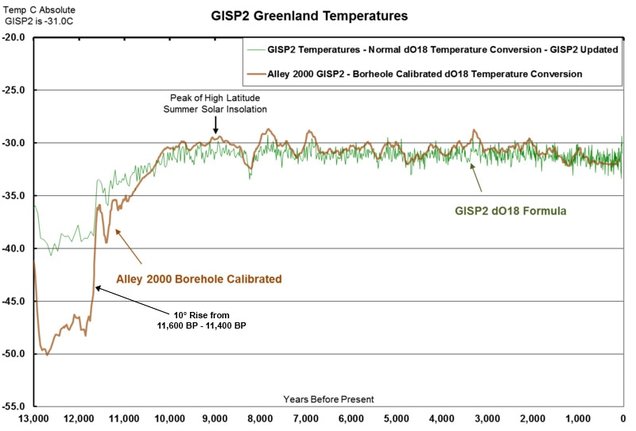
Figure 23: GISP2 Greenland temperatures(Richard B. Alley. 2000)
In a paper titled, "Climate change and human origins in southern Arabia.” Dr. A.G. Parker and Dr. J.I. Rose state, " Marine cores from the Indian Ocean, Gulf of Oman, and the Arabian Sea provide a detailed history of the south-west Indian Ocean monsoon system throughout the Quaternary. Biogeochemical and lithogenic data from Arabian Sea cores spanning the last 350,000 years also support the notion that monsoon winds were sensitive to changing glacial climates. The retreat of ice sheets, the rise in continental albedo (solar radiation reflected off the earth’s surface), and the increase of water surface temperatures in the western Indian Ocean triggered spikes in magnitude (Clemens. 1991). Computer simulations have been used to estimate the average wind speed of the south-west monsoon during such phases of intensification. Speeds currently average around 10 m/sec, while increased periods of activity saw wind speeds reaching 15 m/sec. Precipitation would have been 50 % greater than its present value, growing from 5 mm/day to 7.5 mm/day. Northwards-shifting insulation patterns drove the monsoons further into the Arabian Peninsula, with evidence for seasonal storms reaching as far north as Bubiyan Island in the Arabian Gulf (Sarnthein. 1972; Kutzbach. 1981)."(5)
According to the two men, "Data derived from published sources as well as new evidence collected by the authors in the field. Based on a total of 396 absolute dates, present us a composite sum probability curve(Figure 24) to illustrate climatic oscillations over the past 175,000 years, from MIS 6 to present. Peaks in sum probability represent periods of increased wetness, while troughs highlight drier phases. All dates are reported in calendar years BP."(6)
According to the two men, "Data derived from published sources as well as new evidence collected by the authors in the field. Based on a total of 396 absolute dates, present us a composite sum probability curve(Figure 24) to illustrate climatic oscillations over the past 175,000 years, from MIS 6 to present. Peaks in sum probability represent periods of increased wetness, while troughs highlight drier phases. All dates are reported in calendar years BP."(6)
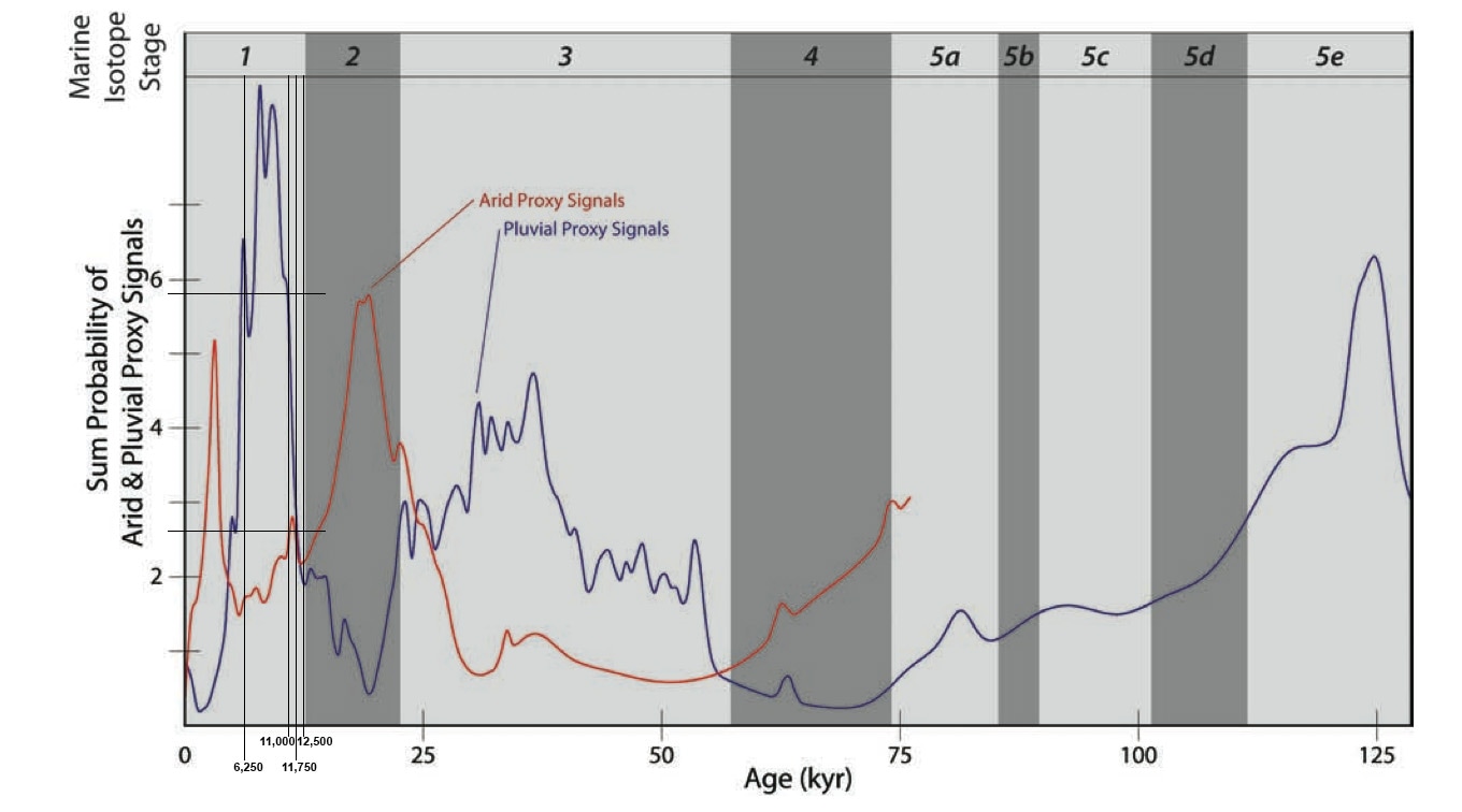
Figure 24: HOPE ENV sum probability curve depicting wet/dry signals throughout Arabia during the upper Pleistocene.
In figure 24 we can see that from 11,700 BP to 11,000 BP the sum probability of Pluvial Proxy Signals rapidly spikes. If this is to represent an increase in wetness as Dr. Rose and Dr. A.G. Parker conclude(A.G. Parker &. J.I. Rose. 2008), then we can see from their work that this narrow period of time is the fastest increase in moisture this part of the world had seen in over 175,000 years.
This conclusion is supported by Dr. Douglas J. Kennett's and Dr. James P. Kennett's research paper titled, "Early State Formation in Southern Mesopotamia: Sea Levels, Shorelines, and Climate Change." In their research paper they concluded that, “The changes in Holocene precipitation and associated shifts of the Sudanian-Sahelian vegetation belt over north Africa (Roberts 1989), the Arabian Peninsula, and southern Mesopotamia have been linked to changing intensification of summer monsoons related to northward shift of the Intertropical Convergence Zone (Clemens. 1996; COHMAP 1988; Kutzbach 1983; Kutzbach and Guetter 1986; Roberts and Wright 1993; Street-Perrott and Roberts 1983). Holocene fluctuations in the strength of the South Asian monsoon in the Middle East region resulted from differential thermal response of land and ocean surfaces due to orbitally caused (Milankovitch) changes in the strength of the seasonal cycle and solar radiation in the Northern Hemisphere (Clemens et al. 1996; Kutzbach and Gallimore 1988; Kutzbach and Guetter 1986). The resulting increase in airflow over Arabia from the Indian Ocean, associated with south-west summer monsoons, led to higher seasonal precipitation (Kutzbach and Guetter 1986) and upwellings near south Arabia that peaked about 9000 BP (Prell 1984). Increased monsoonal strength during the Early Holocene led to the higher annual precipitation as far north as southern Mesopotamia (Kutzbach and Gallimore 1988; Kutzbach and Guetter 1986; Roberts and Wright 1993; Whitney et al. 1983). Conditions further north remained relatively dry. (Kutzbach and Guetter 1986; Roberts and Wright 1993)”(7)
We can also find this conclusion supported in Dr. McClure work. McClure has researched the last 100,000 years of climate in this part of the world, stating in his 1984 paper at London University that, “The new date for the virtually trackless Rub' al-Khali desert in the Arabian Peninsula showed broad matches with the climate histories of a whole belt of deserts that includes the Simpson in Australia, the Rajasthan in India and the Kalahari and Sahara in Africa. The great Rub' al-Khali desert began to form more than two million years ago, while the lakes were formed just yesterday in geological terms." He speculates, “that the summer monsoon moved to the north twice in recent geological history, most likely creating lakes in what he calls "one-time fill-up incidents. It would rain like hell one monsoon season and then not rain in a particular area for the next 10 or 100 years. The lakes had no links with rivers, above or below ground, or any other source of continuous replenishment, and their bed sediments presented no evidence of regular refilling. Rub' al-Khali lakes "weren't enormous lakes like in East Africa or like Lake Superior." They probably ranged in depth from two to 10 meters (6 to 32 feet), but they extensively covered an area 200 miles by 300 miles. A few of these lakes may have lasted several years, but most existed only a few months to a few years. The monsoon's movement to the north, which is also strongly suggested by the climate histories of the deserts in Africa, India and Australia, may have been due to a slight wobbling of the earth in its orbit around the sun. In a 1981 study, John E. Kutzbach of the University of Wisconsin's Center for Climatic Research argued that such shifts would have resulted in hotter summers in the northern hemisphere, in turn creating a low-pressure corridor through the Arabian Gulf and present-day Iraq which provided a passageway for the inrush of moisture-bearing air from farther south.”(8)
Thus from the extensive scientific data that has been conducted so far on the Earth’s changing climate, and its effects on the Indian monsoon system over the last 100,000 years we can postulate that during one of the most extreme periods of global warming, 11,700 BP to 11,000 BP years ago, there is a high degree of probability that one or more of the Indian summer monsoons altered their path and were pulled northward towards the Gulf Oasis, thus heralding the beginning of
the Arabian Holocene Sub-pluvial.
If this is the case, and a single Indian Monsoon system made its way across the Gulf Oasis at around the same time the rising ocean had killed the largest freshwater ecosystem this part of the world had ever known 11,500 years ago, a minimum of 10 meters would have fallen in this part of the world. This is because the same monsoon system in less turbulent times has been recorded to have dumped 10 meters of water or 9,300 mm (366 in) in July 1861 in Cherrapunji, India,(9)
This rapid increase in water would have caused the ocean that lay approximately -77 meters below current sea level as seen in figure 25 below, to rise another 10-15 meters over a 4- 6 week period(T.N. Krishnamurti. 2009)
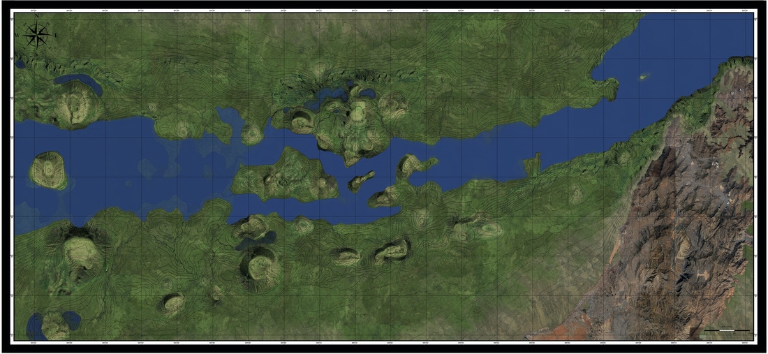
Figure 25: Gulf Oasis with the ocean at a depth of -77 meters circa 11,400 BP.(Dold. 2016, Lambeck. 1996; Fairbanks, R.G. 1989)
This would have resulted in the water level to have risen to -64 meters below current levels in a matter of 40 days or less, adding insult to injury to our early ancestors who occupied this part of the world for more than 50,000 years.
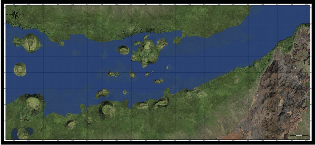
Figure 26: Gulf Oasis with the ocean at a depth of -64 meters 40 days later.(Dold. 2016, Lambeck. 1996; Fairbanks, R.G. 1989)
In conclusion, by combining the separate research of many eminent scientists, historians, archaeologists, and the first highly detailed reconstruction of the sea floor of the Strait of Hormuz, we can see that there was an oasis that was significant enough to have housed the first humans that migrated out of Africa. An oasis that would have been able to have supported the beginning of agriculture and the birthplace of human civilization. However, with recent scientific evidence, it reveals that two very significant flooding events occurred in this oasis approximately 11,400 years ago, ending any human occupation that may have occurred within one person’s lifetime. The first was the rising of the ocean into this antediluvian plain. According to Lambeck's and Fairbank's research, approximately 11,600 - 11,400 BCE the ocean had risen enough to flood and kill the greatest freshwater system this part of the world had ever known, resulting in the loss of 1000’s of ecosystems, and a way of life our ancestors had developed for over 50,000 years. The second significant flooding event that has been shown to have possibly occurred during this time frame came from the first of several cataclysmic storms that travelled from the south. Within a very brief period of time, 40 days or less, the Indian Monsoon would have been pulled north and would have caused the water level in this area of the world to rise at least another 10-15 meters. A storm that would have caused a large group of people to become displaced from this land forever.
It is impossible to say with any certainty that these events are reflected in the mythology that originates from this area, but “What If” the stories we have from our ancient past are in fact from those people who experienced a dramatically changing world.
As an artist, the myths that spring from this region of the world are rich with imagery and symbolism, in particularly the Enuma Elish. The earliest creation/flood myth known to man. It is through the fantasy world of art that I would like to explore the relationship of this ancient myth to the events that transpired in this region of the world. The works of art that are represented in my body of work are in no way an attempt to say that these myths are attached to the catastrophic events illustrated in this paper, only an attempt to explore the world of "What If!"
Footnotes
(1) Jeffrey I. Rose - 2010 - New Light on Human Prehistory in the Arabo-Persian Gulf Oasis - Current Anthropology Vol. 51, No. 6, pp. 849-883 -The University of Chicago Press on behalf of Wenner-Gren Foundation for Anthropological Research
(2) Jeffrey I. Rose - 2010 - New Light on Human Prehistory in the Arabo-Persian Gulf Oasis - Current Anthropology Vol. 51, No. 6, pp. 849-883 -The University of Chicago Press on behalf of Wenner-Gren Foundation for Anthropological Research
(3) Theresa Howard-Carter - 1981 -The Tangible Evidence for the Earliest Dilmun - Journal of Cuneiform Studies - Vol. 33, No. 3/4, pp. 210-223 - The American Schools of Oriental Research
(4) Jeffrey I. Rose - 2010 - New Light on Human Prehistory in the Arabo-Persian Gulf Oasis - Current Anthropology Vol. 51, No. 6, pp. 849-883 -The University of Chicago Press on behalf of Wenner-Gren Foundation for Anthropological Research
(5) A.G. Parker &. J.I. Rose. 2008 - Climate change and human origins in southern Arabia - Proceedings of the Seminar for Arabian Studies 38: 25–42
(6) A.G. Parker &. J.I. Rose. 2008 - Climate change and human origins in southern Arabia - Proceedings of the Seminar for Arabian Studies 38: 25–42
(7) Douglas J. Kennett1 and James P. Kennett. 2006 - Early State Formation in Southern Mesopotamia: Sea Levels, Shorelines, and Climate Change - Journal of Island & Coastal Archaeology, 1:67–99, Taylor & Francis Group
(8) McClure H. 1984 - Late Quaternary palaeoenvironments of the Rub’al Khali. PhD thesis, London, University of Central London.
(9) T.N Krishnamurti. 2009 - Indian monsoon - Encyclopedia Britannica - http://www.britannica.com/science/Indian-monsoon
References
Spencer Wells. 2004 - The Journey of Man: A Genetic Odyssey Paperback – February 17
Fairbanks, R.G. 1989 - 17,000-year glacio-eustatic sea level record: influence of glacial melting rates on the Younger Dryas event and deep-ocean circulation.
Jeffrey I. Rose. 2010 - New Light on Human Prehistory in the Arabo-Persian Gulf Oasis - Current Anthropology Vol. 51, No. 6, pp. 849-883 - The University of Chicago Press on behalf of Wenner-Gren Foundation for Anthropological Research
Theresa Howard-Carter. 1981 -The Tangible Evidence for the Earliest Dilmun - Journal of Cuneiform Studies - Vol. 33, No. 3/4, pp. 210-223 - The American Schools of Oriental Research
Lambeck. 1996 - "Shoreline reconstructions for the Persian Gulf since the last glacial maximum” - Research School of Earth Sciences, The Australian National University. Canberra, ACT 0200, Australia
A.G. Parker &. J.I. Rose. 2008 - Climate change and human origins in southern Arabia - Proceedings of the Seminar for Arabian Studies 38: 25–42
Peter A. Underhill. 2000 - "Y chromosome sequence variation and the history of human populations" - Nature Genetics 26, 358 - 361
Douglas J. Kennett1 and James P. Kennett. 2006 - Early State Formation in Southern Mesopotamia: Sea Levels, Shorelines, and Climate Change - Journal of Island & Coastal Archaeology, 1:67–99, Taylor & Francis Group
V. Gordon Childe. 1928, 1934, 1952, 2015 - New Light on the Most Ancient East - Routledge & Kegan Paul
Douglas G. Martinson. 1987 - Age Dating and the Orbital Theory of the Ice Ages: Development of a High-Resolution 0 to 300,000-Year Chronostratigraphy - University of Washington
Arthur Clark. 1989 - Lakes of the Rub' al-Khali - Saudi Aramco World on pages 28-33 of the May/June 1989 print edition.
Jeffrey I. Rose. 2008 - Climate change and human origins in southern Arabia - Volume 38, Papers from the forty-first meeting of the Seminar for Arabian Studies held in London, 19-21 July 2007 - Archaeo Press Oxford
S.C. DeMeo. 2000 - Response of water level to barometric pressure and Earth tides in well PM-2, March 1-April 30, 1997, Pahute Mesa, Nevada Test Site - http://pubs.usgs.gov/wri/WRIR00-4014/text/sources.htm
Richard B. Alley. 2000 - The Younger Dryas cold interval as viewed from central Greenland - Quaternary Science Reviews 19 - Elsevier Science Ltd.
T.N. Krishnamurti. 2009 - Indian monsoon - Encyclopedia Britannica - https://www.britannica.com/science/Indian-monsoon
McClure HA. 1976 -Radiocarbon chronology of late Quaternary lakes in the Arabian Desert. Nature263: 755–756
McClure H. 1984 - Late Quaternary palaeoenvironments of the Rub’al Khali. PhD thesis, London, University of Central London.Late Quaternary
Ahmed Al Dughairi. 2007 - Palaeoenvironmental Reconstruction in the Burydah Area, Central Saudi Arabia - Department of Geography University of Leicester
West, A., Kennett, J.P., Mayewski, P.A., Bunch, T.E., Stafford, T.W., Ballard, J., and W.S. Wolbach. 2015 - Evidence for major, widespread biomass burning at onset of Younger Dryas (12.8 ka).
Kinzie, C.R., Que Hee, S.S., Stich, A., Tague, K.A., Mercer, C., Razink, J.J., Kennett, D.J. Decarli, P.S., Bunch, T.E., Wittke, J.H., Israde-Alcantara, I., Bischoff, J.L., Goodyear, A.C., Tankersley, K.B., Kimbel, D.R., Culleton, B.J., Erlandson, J.M., Stafford, T.W., Kloosterman, J.B., Moore, A.M.T., Firestone, R.B., Aura Tortosa, J.E., Jordá Pardo, J.F., West, A., Kennett, J.P., and W.S. Wolbach. 2014 - Nanodiamond-rich layer across three continents consistent with major cosmic impact at 12,800 cal BP. Journal of Geology, Vol. 122, No. 5 (September 2014), pp. 475-506
Fiedel, Stuart. 2009 - "Sudden Deaths: The Chronology of Terminal Pleistocene Megafaunal Extinction" - In Haynes, Gary. American Megafaunal Extinctions at the End of the Pleistocene. Springer. pp. 21–37.
